Bataille de Llinas ou Cardedeu : 1ere Position [y] 2éme...


 Maps, plans and nautical charts
Bataille de Llinas ou Cardedeu : 1ere Position [y] 2éme Position (1813)
Maps, plans and nautical charts
Bataille de Llinas ou Cardedeu : 1ere Position [y] 2éme Position (1813)
 Disponible Holdings
 Section: Maps, plans and nautical charts
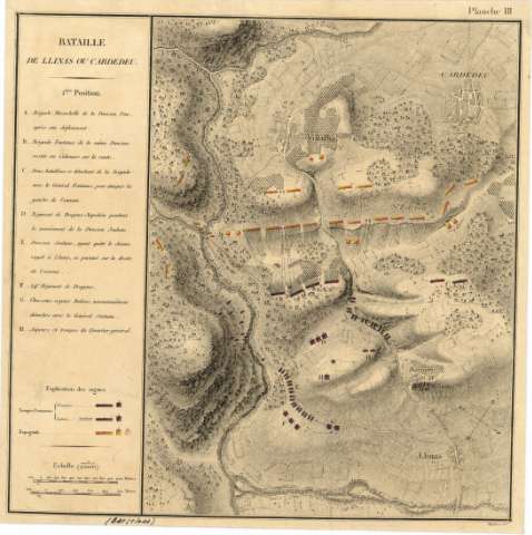
Title: Bataille de Llinas ou Cardedeu : 1ere Position [y] 2éme Position / Orgiazzi scl
Material or type of resouce Area: Escala 1:25.000
Publication: [Lugar de publicación no identificado] : [Editor no identificado], [1813]
Physical description: 1 mapa en 2 h. : col., montado sobre tela ; en h. de 26 x 26 cm
Content type: Imagen cartográfica
Media type: computadora
Carrier type: recurso en línea
Notes: Comprende parte de los términos municipales de Cardedeu y Llinás, en la provincia de Barcelona
Fecha tomada del catálogo del SGE: "Cataluña. Provincia de Barcelona, Siglos XVI a XIX". 1970, p. 241
Escala también dada en forma gráfica, de 1.000 metros y en 500 toesas. Orientado con flecha en cuadrante
Relieve representado por normales
Relación de las posiciones de los distintos batallones, brigadas, divisiones y regimientos del ejército francés e italiano, indicada por clave alfabética
Tabla de signos convencionales para señalar los ejércitos francés, italiano y español
En el ángulo superior derecho de cada una de las hojas figura: "Planch III" y "Planche III Bis"
Materia / lugar / evento: Llinás (Barcelona)
Cardedeu - Operaciones militares - 1813 - Mapas
Nombre jerárquico lugar: España - Cataluña - Barcelona - Cardedeu
España - Cataluña - Barcelona - Llinás
Other authors: Orgiazzi, J. Alexis
Related titles: CARDEDEU (Barcelona) (Término municipal). 1:25.000
UDC: 912:355.43:355.4(467.111.4)"1813"
467.111.4 Cardedeu, Término Municipal
467.111.4 Llinás, Término Municipal
Type of publication:
Maps
Rights:
Préstamo:
Disponible
Préstamo:
Disponible
